One of my goals on this last trip out west was to find the “not so normal”. Sometimes you can plan those destinations out ahead of time, and sometimes, they just find you. During this trip there was equal parts of both. One of the plans was to visit a real ghost town, and if you’ve read my other posts Going West Pt 2 and Southwest 2012: Eldorado Canyon Mine you will see that I was fairly successful in that quest. I will warn you, there would be some failure in this trip.
This first destination while exciting at times, and nearly disastrous at others, was that failure. And I use that term lightly. We made it out alive and managed to capture a few shots as well so “failure” here is a little strong. Staying in Kanab, UT we searched google maps for interesting locations and found the ghost town of “Pahreah” or as it known as now, “Paria”.
Paria as per Wiki:
The area was first settled in 1865 by a Mormon group led by Peter Shirts. This early settlement was named Rockhouse, for Shirts’s strongly built sandstone house. After the end of the Black Hawk War in 1867 settlers began to arrive at a rapid pace. Farming produced good crops for several years, but irrigation was very difficult; each spring the surface runoff water was absorbed into the desert soil too quickly to properly water the fields. In 1870 the residents agreed to move the settlement. They divided in two groups; half the people went about 5 miles upstream and founded the town of Pahreah.
In 1871, John D. Lee came to the Paria area, fleeing investigators of the Mountain Meadows massacre. He constructed a dam and irrigation ditches with the help of many locals and passersby, including members of John Wesley Powell’s second Colorado River expedition.
Pahreah grew through the 1870s, gaining a general store, a church, a number of sandstone houses, and many log houses. The population grew to 47 families. The town hit hard times in the 1880s, however. The Paria River flooded every year from 1883 to 1888, washing away fields and even some buildings. People started to move away. By 1892 there were only eight families left, but for some reason the town was granted a post office that year, under the name Paria. Not much changed until a small gold mining operation was established here in 1911. Within a year, that too was wiped out by flooding. The post office closed in 1914. A lone bachelor prospector held out until 1929, then Paria was empty.
Filming location
In later years the film industry became interested in using the picturesque ghost town, with its canyon vista background, as a location for making Westerns. Several scenes for Buffalo Bill were shot here in 1943, but crews were in a constant struggle against the flooding Paria River. Producers of other movies and television programs used Paria more or less throughout the 1950s. Then in 1961 the old ghost town was used as a major location for the Rat Pack film Sergeants 3, the largest western ever filmed in Kane County. Not satisfied with what remained of Paria, the film’s creators constructed an imitation Old West town about a mile to the west. Visitors often confused this movie set with the real Paria, as it fell into disuse after the filming of The Outlaw Josey Wales in 1976. After more flash flooding severely damaged the set in 1998, a team of volunteers and employees of the Bureau of Land Management disassembled the wreckage and replaced the structures in 1999–2001. New interpretive signs explained the movie set’s significance and distinguished it from Paria itself.
So we drove our new Hyundai Veloster out west for this trip. It is a great economical car with a great ride and it turns out, quite an off-road vehicle as well. Without too much trouble we found the road entrance to Paria. Now, before I continue, there is one thing you should know about Utah roads. Just because the road you turn onto is paved, doesn’t mean it will stay that way for long, nor will it be indicated when that change will occur. Now this would be great if I owned a 4×4 off-road vehicle, but not in my Veloster which has 4 inches of ground clearance, maybe. Oh well, we have insurance and a good warranty so off on the dirt road we go. The road quickly goes from dirt to dirt washboard and stays that way, for the next 4 miles. At the end of the 4 miles, the road turns to trail and now we are crossing wash-out beds and muddy rutted trails. Suddenly the road/trail, just goes away and we are at the foot of a large rocky butte with nothing but a field of cracked earth below us. It is at this point, we decide we may have gone the wrong way. We are also too far out, and starting to get into hardcore 4×4 country. We turn back and find the junction we miss and it takes us to what looks like, yes, in the middle of nowhere, a restroom and stop.

After a quick bathroom break and wandering around a bit we find a couple of plaques that inform us that the ghost town we are looking for was washed away by floods and that there is another, the movie set, about 2 miles up the road, er, trail. So we hop in the car and head out in the direction the maps shows. Around the first bend we are faced with a creek to cross and not with a bridge. It is the end of the line for us. It wasn’t until I sat down to write this entry did I find out through some extended research that the movie set was burned down by suspected arsonists in 2006. This hits close to home for me as I see this in the urban exploration world quite a bit. Beautiful historic sites are often lost to vandals and scrapers. We get turned around and head back to a pull off we saw on the way in.
On the way in there were about 20 photographers mobbing this area. Now, 45 minutes later it is completely desolate. Here is a full resolution 360 degree panorama of the area. This final shot consisted of 84 vertical frames and was shot using a tripod and a Sigma 50mm 1.4 APO lens.
Click Here to load the 360degree Shot in a new Window
Here is a nice shot of chasm I perched myself on for the shot, sans car.
On the way out, because we have to keep our speed to around 5 miles an hour on the washboards, we take a few stops to view the local flora. Throughout the desert beautiful flowers dot the landscape.
We decide to head off to Page, AZ and destination we are a little more sure of. Along the way, outside of Page we stop at in information center and the nice attendant there tells us of a great overlook just outside of Page that most miss on their way through. We decide to check it out. Our instructions include looking for the Denny’s outside Page and heading around back and down a road that we will find there. I have followed stranger instructions. Along the way we make a stop at an offshoot of Lake Powell called Wahweap Bay. Wahweep is located just North of the Glen Canyon Dam and our secret scenic destination and is part of the snaking Lake Powell.
Before heading to the secret overlook we decide to hit a car wash and clean the mud and sand off the car and grab lunch at local BBQ in downtown Page. We have a great BBQ sandwich at Big John’s Texas BBQ and head over to the Denny’s to find this secret overlook. Without too much trouble we find the road to the overlook. Upon first look this place doesn’t look too scenic. After exploring a bit we find a natural trail down the sandstone to a hidden overlook of Dam and Glen Canyon for which it is named.
All around the scenic overlook are beautiful layered sandstone cliffs.
This natural and somewhat uniform erosion makes for some interesting abstract shots.
Time to climb back up the cliff and head out to find the elusive Toadstools. They are not to difficult if you have a little direction. I will make it easy on you and provide the Google maps address to save you some time, but remember, leave nothing but footprints and take nothing but photographs! You can find the trail entrance on Route 89 between Kanab, UT and Page, AZ here: GOOGLE MAP LINK The trail is for foot hiking only and about 1 mile long to to reach the toadstools. The elevation change is only about 100 feet but it can be blistering hot and the trail is sand and can sap your strength quickly. Make sure you take water with you and know that cell phone coverage is not existent. The trail can be challenging in some areas but nothing over moderate. Here is one of the more unique parts of the trail.
It was about 93F out and very little breeze. The only relief was when we could catch a cool breeze in a shadow cast by one of the surrounding canyon walls. All along the route lizards scattered from our path, several species of large insects scurry about and we also run across some cool tracks in the dry creek bed. Care to take a guess?
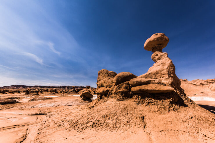
We had originally thought that maybe a hiker brought along their dog but there were no accompanying human tracks. After further research I discovered that they were coyote tracks. There were so many of them that the canyon must be loaded with them at night. Finally we make it to the toadstools. The toadstools are spire-like feature with a boulder perched atop a pedestal rock, like a mushroom, or “toadstool.” They form when softer rock erodes away, leaving a column sheltered from wind and water. This area is very unique and conditions are perfect for the toadstool development.
A vigorous climb up a sandy mound opens up to a large amphitheater where the toadstools reside.
With some further exploring up the mesa I come across the water source for the area. This is actually a dried up waterfall. This really must be fantastic during the flash flood season.
Along the ridge, further up the trail there are more toadstools in different formations. This is such a beautiful area, and though we passed a couple on the way in, there is no one here. The quiet, plus the lack of people milling about just lends to the magical quality of this place.
Unfortunately, some malicious people feel the need to knock over these amazing formations. If you go there, I cannot stress to you enough, be kind to the land. These things take thousands of years to create, don’t let 5 minutes of stupidity ruin it for others.
As with many of the destinations I visited out west this year I brought along the looking-glass for some variety.
During my entire shoot this little guy hung out with me. I make such great friends on my travels!
The sun is setting and it is time to make the 1 mile trek back to the car and the 40 mile trip back to home base in Kanab. On the way back we run into this guy.
That my friends is the Darkling Beetle. A big boy for sure, and also known as the Utah Stink Beetle. If he is disturbed he will stick his rear in the air and let you have it. Luckily, we did not piss him off. Well, for a day that started out nearly disastrous, it turned out pretty great. We say goodbye to the toadstools and head back, for tomorrow, we hunt for GOBLINS!!
The next day we are up early as this will be one of the longer journeys from home base for us. Goblin Valley State Park is located about 216 miles southeast of Salt Lake City near a small town called Hanksville. That won’t help you find the place though. Best to have a GPS, and the last 12 miles of desert road into the park will have you watching your rear view mirror for Leatherface and his pick-up truck.
Touted as Utah’s most popular park we were hoping that it won’t be too crowded to get some shots. The drive into the park entrance is un-assuming and rather boring. You pass by a couple of hoodoos and think, “This is it?” Then you reach the over look to the basin and realize this is going to be a LOT of fun! We hike about 50 yards down the hill from the over look and are instantly thrust into something akin to the movie set from the “Dark Crystal” What?? You didn’t think I would get through this entire series without a crazy 80’s SciFi movie reference did you? Don’t worry, there will be more I am sure. This place is truly fantastic!
Every angle, every step changes what you see. A face here, a character there, a truly remarkable experience. Some look like little gnome homes.
Others, look like the gnomes themselves. Ooh, nice hairdoo Elvis!
How about H.R.Puff-n-stuff delivering a pizza? Okay, too old? How about Jabba the Pizza Hut? (Sorry, I couldn’t resist)
Goblin Valley is about 4.686 square miles of fun shapes, mazes and cool places to explore. Let’s dispense with the commentary for a bit and explore. You can imagine for yourself what some of these remind you of.
See what I mean? The fun here is literally never-ending. No fences, gates, just a big playground that changes all around you. In addition to the hoodoos, the desert floor changes color beneath you as well. Here you can see where the flash flooding has deposited some nice white sand among the typical orange.
When you are tired, all this reminds you of is a nice cold orange creme-cicle. Unfortunately, there are none of those for miles around. I digress. For 90% of this trip it has been virtually weather free and when shooting landscapes it is preferred to have some clouds for drama in the sky. About halfway through today’s exploration the wind started to get violent. Dust devils come out of nowhere. After much dodging and diving behind hoodoos to avoid a good sandblasting, the winds move on and a nice wispy cloud front moves in.
Because of the nice clouds, this next shot is one of my favorites on the day.
It’s a little alien, it’s a little earth. Speaking of aliens, this really reminds me of an alien spine.
Taking that a bit further, here is an infrared treated hoodoo that looks a bit out of this world I think.
Without too much imagination you can easy think yourself lost on another planet which is quite understandable seeing that the Tim Allen movie Galaxy Quest was shot here for that very reason. I have never actually seen the movie but I have looked at the stills on IMDB. I may have to check it out on Netflix now that I have been there.
This place is so vast, it makes perfect sense why they put the trail head and entrance up on a hill overlooking the park. You can scan the horizon at any time and find your bearing. With nearly no one in the park today it would otherwise be very easy to get lost here. This one kind of reminds me of Jar Jar Binx for some reason.
While some of the hoodoos represent single figures or villages, some of them clearly define why the park is called “Goblin.” In these next shots you can see what looks like little hooded goblins standing around passing judgement and plotting hi-jinx against the passers-by.
Did you see? Yep, they were definitely plotting! Okay, maybe I needed some water and shade at this point. 2 sides of the park is surrounded by giant sentinels standing over the goblins in the form of steep canyon walls.
Some look like they could be kings castles!
Even the Navajo spy plane is too scared to stick around.
And a view of the crow’s nest as if on an old pirate ship of rock and sandstone with the Sigma 70-200mm @ 75mm. Love the versatility and clarity of this lens.
It is also the go to lens for use with my looking-glass. I set the f/stop as wide open as I can stand it to blur the background and draw the viewer into the scene within the ball. Here are my “looking-glass” shots from Goblin.
Have to put the ball away before I burn myself and a goblin. Off in the distance I spy a slot canyon entrance.
Unfortunately, the shadows are growing long, and time is growing short for shooting. A couple of the shots that I wanted to get while here were panorama from down on the floor of the canyon and then one from the overlook. I find the ideal spot and set up the shot. Using the tripod and the camera set up vertically I proceed to shoot a complete 360 degrees to cover the entire area.
That shot took a total of 42 frames shot at 20mm and then assembled in Photoshop using Photomerge. We climb up the hill to the overlook to do another. This shot is about 180 degrees to basically capture a view of the entire park and the nice sky overhead.
What a great day playing with the goblins, time to head out. As we exit the park and prepare for our long journey home I pull off briefly to take a photo of the 3 wise goblins that guard the parks entrance. I think this single photo sums up the magic of this place. Definitely do not miss Goblin Valley State Park when visiting Utah. It’s not the biggest, but it is among the best.
If you enjoyed this blog, please consider purchasing a few prints to help fund my travels. Make sure to keep an eye out for the fifth and final entry in this series, coming soon!








This is absolutely terrific, A.D.! Thanks for bringing us along on another of your fabulous photo adventures, it really does make us feel like we were right there with you! GREAT photography, each shot can easily stand on it’s own!