


I have to admit, after touring the west in 2010 and being completely overwhelmed with the vastness and beauty of it all, the thought of touring Maine seemed a bit, anti-climactic. Truth is, I couldn’t have been more wrong.
Park History and Features
Acadia National Park is a National Park located in the U.S. state of Maine. It reserves much of Mount Desert
Island, and associated smaller islands, off the Atlantic coast. Originally created as Lafayette National Park in 1919, the first National Park East of the Mississippi, it was renamed Acadia in 1929. The park includes mountains, an ocean shoreline, woodlands, and lakes. In addition to Mount Desert Island, the park comprises much of the Isle au Haut, parts of Baker Island, and a portion of the Schoodic Peninsula on the mainland. In total, Acadia National Park consists of more than 47,000 acres, including 30,300 acres on Mount Desert Island, 2,728 acres on Isle au Haut and 2,366 acres on the Schoodic Peninsula. Cadillac Mountain, named after the French Explorer of the same name, is on the eastern side of the island. Its green, lichen-covered, pink granite summit is, because of a combination of its eastern location and height, one of the first places in the United States to see the sunrise. Miles of carriage roads were originally built by John D. Rockefeller, Jr. The mountains of Acadia National Park offer hikers and bicycle riders views of the ocean, island lakes, and pine forests. The inlet Somes Sound, often described as the “only fjord on the East Coast”, is now called a fjard by officials. Acadia has the distiction of being the only National park in the Northeastern United States.
I spent 2 days in Acadia during the summer of 2011. While this was plenty of time to get a taste of the park, it was nowhere near enough time to totally experience it. I put months of planning into these trips to maximize my shoot time within a condensed frame. There are usually 4 or 5 shoots along the way to and from my big destination so an itinerary is a must. I use AAA route planner, Google Maps and Google Earth to plan my driving and major destinations. Then within those major destinations I will seek out smaller more remote areas to shoot. I then combine those with weather, sun position, and seasonal conditions to best map out my limited time in each area. I takes a lot of planning and is totally frantic right up until the departure day, but once the trip is underway it all feels right and allows me to relax and focus on shooting.
The Adventure ~ Day One
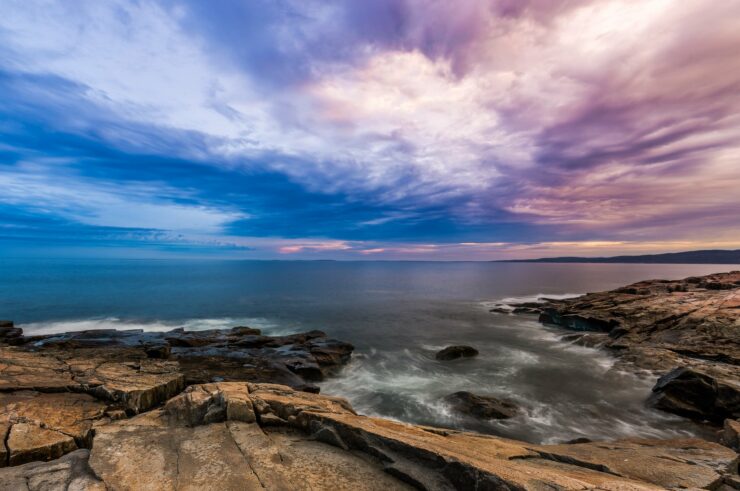
The first place on my list at is the at the base of Cadillac Mountain. A well known area called Sand Beach at Newport Cove. It is a popular swimming destination as it is a fairly protected lagoon with a gradual depth change. Aptly named, Sand Beach has to be one if not the only sand beach in the park. Most of the beaches in Acadia are very rocky and treacherous. I had done some studying up on the Maine coast and was looking to find that rocky flavor to feature in my shots. Sand beach luckily was surrounded by a couple of very forgiving areas to get my feet wet, so to speak. Just as I had envisioned, to the right of the public swimming area was this very photogenic cliff.

As I started to climb out on the dry portion of the rocks I quickly realized that dry did not mean stable for footing. The rocks, though dry and rough where extremely slick, my first few steps where nearly disastrous. I actually found that the kelp covered rocks where much easier to navigate. I wasn’t sure if it was due to the lack of slickness or the fact that my subconscious expected those rocks to be slippery and I was more careful on them. After snapping a few brackets I spied another rocky area to the left of the beach and headed off that way. One very cool thing about Acadia is that you can pretty much hike anywhere you dare. I love this freedom in National parks as it lends quite well to my creative side. This area is a little more remote and allows me to frame up a couple of different shots to my liking.


The tide lines are quite high here and though you may not see it at first, these beach areas that are un-covered when the tides are out are teaming with life. If you travel to Acadia, please be mindful and tread lightly. Wrapping up, I head back to the car and drive the park loop toward Otter bay. About a mile down the coast I pull over to do some more cliff climbing. Reluctant at first, these rocks were much larger and less slick. So down the rocks I go. I got so wrapped up in exploring the cliffs that I almost forgot I was there to shoot. The waves where crashing quite nicely here.

After some continued climbing I stumble upon my first tide pool. A tide pool is an area that remains full of water after the tides have gone out. Whole specialized ecosystems reside in these pools. They are extremely colorful and chock full of critters.


Here is a highpoint panorama of Newport Cove overlooking the tide pool (lower left)

After nosing around the tide pool a bit, it seems that there is more life here than meets the eye. Here a small crevice is filled with barnacles and shellfish of some sort hanging on to the last bit of water.

As I have my eye trained on the rocks I notice what appears to be, yes…a Bear track.

After hanging out an the tide pools for awhile I decided to tour on through the park a bit. It was suggested that I check out a little known part of the park, North the Desert Island called Schoodic Point. Upon first glance of the map you would not think it part of Acadia but I assure you it is. The cliffs are a little more dangerous here but as in any national park, if you use common sense, you should be fine. The point gives a beautiful view of Desert Island and the Cranberry Islands in the distance, and you’re at all like me and like to get away from the touristy areas, this is the place to check out. There were a few people around but not nearly as many as in the main park. And in my opinion, the beach view here is better.

As you can see, the surf here is a little more active. Deep ruts from ancient lava flows make for some large crashes.


A youth looks on as a big wave crashes the cove.

The granite bedrock cliffs here are kind of unique here at Schoodic as they are striated with basalt dikes. These dikes are vertical lava flows that are black and stand out quite boldly against the pinkish-orange granite.

There is a lot of wildlife in Acadia. Mostly what I saw there was either aquatic or sea going foul. The birds here are definitely used to having people around. While I was shooting in this area I was closely followed by this guy.

These two didn’t seem to mind me using them as models. They kinda had their own thing going on.

The day was getting late and I had plans to stick around for the sunset. Clouds were moving in quick so I decided to throw on my ND filter and do some long exposure work while my lunch (and wild blueberry pie) was being fetch. I found a cool spot right next to a deep cut in the granite. These areas are a little scary as they are very deep and filled with surging water. I think I have the fear of falling in one of these things and being trapped during the tide coming in or something. They make me nervous while shooting around them. I set up just to the left of one of the larger crevasses to get my shot.

My lunch arrives and I put the cameras away for a bit and just enjoy my sandwich and fresh homemade pie. There are several small diners that serve fresh wild blueberry pie. I highly suggest you find one while you are there and grab a slice to enjoy on the beach as the sun sets. Having stuffed myself, I literally rolled over to my camera bag, sat up and took this shot. One of my favorites from the day.

I picked up my lunch particulars, grabbed the camera back and walked down the beach/cliffs about 300 yards and was treated to a dazzling sun ray display over Desert Island. I quickly grabbed the camera to capture the show.


The rocky coast of Maine and Acadia is quite impressive. I would be remiss if I didn’t mention the hardy and lush plant life and forests in and around Acadia. The cool thing about Schoodic Point is that while shooting the spectacular coast, right behind you is a forest that is loaded with driftwood, twisted trees, lichen, and bush. Everywhere along the cliffs you will find tufts of sea grass like this one.

The farther you hike and climb along the Schoodic coast, the more lush the foliage becomes until it seemingly takes over the beach completely.


The trees here are all gnarly from the harsh winters. They really take on an other-worldly look. In fact all of Acadia takes on almost a fantasy land, Mordor like atmosphere. The more you explore, the more surreal it gets.

Wanting to see more I headed up the cliffs and inland a bit. If you study the branches in the lower part of this next photo you can see that the branches seem to grow together like a web or netting. I had never seen anything like this anywhere. Pretty amazing.

Moving up the hill a bit more I discovered this driftwood tree that reminded me of a Komodo Dragons head. The colors and textures were just awe inspiring.

Heavy clouds were moving in and the sun was nearly down. I feared that there would be no spectacular sunset that I had waited all day for. I would just have to wait and see. I generally never give up on this sort of thing. The same could not be said for the rest of the park goers. I was now the lone explorer on Schoodic point. Knowing that I was still about 45 minutes away from sundown I broke out my trust ND filter and went for another long exposure/atmospheric type shot of these awesome trees.

I have to admit, it was pretty cool being all alone in this part of the park. Very peaceful and calming. Turns out, it was well worth the wait.

Having got my sunset shot I started to pack my gear. I thought to myself that it really is true that there is never a bad sunset in Acadia. Little did I realize what was going on behind me as I was packing. All of a sudden the entire area started to light up bright pink. I quickly scrambled to get the camera equipment back out to get a shot.

This time, the sun was down for real and I was beat. I had been going hard for about 12 hours, it was time to head to the hotel and hit the hay. Tomorrow would be another adventure.
The Adventure ~ Day Two
Through talking to a few people in my travels from the day before a small hiking area on the outskirts of Acadia called “Wonderland” was first on the list this day. Even the drive in is pretty cool.

After parking there is a .7 mile hike in to reach the beach. The Wonderland Trail is filled with fantasy type settings unique to the area. If you decide to visit, make sure you take your time while walking so you won’t miss them. The Trail is truly magic and very moody and dramatic for photography. Low growing trees and colorful lichen are everywhere.


All throughout the short trail is a myriad of flora. Lichen beds, flowering bushes, and more.


The trail head ends at the ocean and a small bay. The beach here is partially sandy and quickly turns into rock and really cool round stone. I found several rock stacks here and even a washed up lobster pot.


After crossing the round rock beach which was extremely hard to walk on. I made it to a dried tide pool that had this really cool white seaweed in it. It really looked like it was from another planet.

Still semi-tired from the previous days escapades, I decided to take a rest and build a hoodoo to photograph. Heavy overcast skies where moving in so I had to move quickly. After building this thing I was amazed how it actually stood at such a radical angle. I am sure it didn’t stay standing long.

After finishing up brackets for the shot I decided to head back. I was interested in shooting in historic Bar Harbor and wanted to do so before the impending storm. On the way back through the trail I stopped at this wandering tree with the last sun I would see this day, shining through it’s outstretched branches.

On the drive back I stopped at Winter Harbor to take a few fishing boat shots.


Winter harbor was fairly private and I could only find a couple vantage points to shoot from so I decided to head on to Bar Harbor.
Bar Harbor
The town of Bar Harbor was founded on the northeast shore of Mount Desert Island, which the Wabanaki Indians knew as Pemetic, meaning “range of mountains” or “mountains seen at a distance.” The Wabanaki seasonally fished, hunted and gathered berries, clams, and other shellfish in the area. They spoke of Bar Harbor as Man-es-ayd’ik (“clam-gathering place”) or Ah-bays’auk (“clambake place”), leaving great piles of shells as evidence of this abundance. In early September 1604, French explorer Samuel de Champlain ran aground on a rock ledge believed to be just off Otter Cliffs, and when he came ashore to repair his boat he met local natives. Champlain named the island Isles des Monts Deserts, meaning “island of barren mountains”—now called Mount Desert Island, the largest in Maine.
Upon entering Bar Harbor I was greeted by some famous Maine fog and quite cold temperatures compared to just a few hours before. I headed toward the pier determined to get some authentic fishing boat photos. I was not disappointed.


Much to my delight, docked at the harbor was the famous Schooner the “Margaret Todd”. Built in 1911, she is the last surviving, fully operational sail vessel designed for the herring fisheries. What an amazing ship. Only wish I had time for a cruise.

Quite chilled I decide to take in one of the local eateries for some fine food. I had a great dinner at Testa’s Restaurant on Main Street. Afterwards I stopped Agamont park and took a shot of this cool fountain I found there.

A quick stop on the park loop road to take a shot of the incoming storm. I really thought this shot captured everything Maine for me. The storm coming in, the rocky coast, the boat in the harbor, it all makes me feel “Maine”.

Final destination for this trip was Thunder Hole. Thunder Hole is a small inlet, naturally carved out of the rocks, where the waves roll into. At the end of this inlet, down low, is a small cavern where, when the rush of the wave arrives, air and water is forced out like a clap of distant thunder. Water may spout as high as 40 feet with a thunderous roar! On a calm day, Thunder Hole offers nothing more than another pretty view, but on a stormy day Thunder Hole can be a thrill ride. With the storm moving in, and the seas high chop, I figured it was a shoe-in to be a thrill ride. I parked myself on the cliffs and waited. During my wait I snapped a shot of the daring couple that climbed out over Thunder Hole to share a nice romantic moment.

After a few hours wait and a good soaking, and another piece of wild blueberry pie, YUM, I decided Thunder Hole was a bust. I grabbed my last shot of Acadia and bid farewell.

Well the “sure fail” trip ended up being an amazing experience. So much so, I am planning a return trip soon. Much more time exploring Cadillac Mountain and the rest of Mount Desert Island. Acadia is full of National Park magic, the creative eye should have no problem un-covering its hidden wonders. I cannot wait to return.


Can’t wait to go there! August is too far off!